2015 Fall Travels of the Mercury, Oct. 27th to 29th.
We're going canyoneering in Under Cover Canyon lead by our experienced friends, Raven Woman and Kim. Under Cover is in upper Lost Spring Canyon which flows into Salt Creek. It's challenging, requiring a variety of techniques with some exposure and isn't a beginners route.
Under Cover is a documented canyoneering route. It's in Arches National Park were there are regulations and a permit is required.
The day begins with a 2 hour drive from Moab to the northern section of Arches. This will be our second canyoneering trip to Under Cover. Our first one was last year.
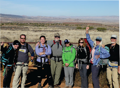 |
| Ready to hike into Under Cover Canyon. |
We arrive at our destination, a fence line that we'll follow across the chaparral to a wash that leads into Under Cover. To look at our photo you'd never guess there were impressive canyons out there.
 |
| We find the right wash and follow it down. |
We follow the fence in and out of many small washes. Our friends know the right one and after about a mile we find it. It's as non-descript as all the rest until we begin the descent.
 |
| The wash becomes a slot canyon. |
Under Cover is a true slot canyon. Walls lean in above us and we slide and stem our way into the crack.
 |
| Following the leader we slide our way into the slot. |
Sometimes the floor of the canyon is a water-filled crack that needs to be stemmed. There had been recent rains and we expected more water in the canyon than we actually found. The canyon floor must drain very well because there are few pools.
 |
| We each have our own way of stemming the water hole. Why get wet feet if we can help it. |
Following are photos of our descent through the slot to our first rappel.
 |
| The always good natured Kim and Jim in the slot. |
 |
| Sometimes you can only see the person ahead of you. |
 |
| Jackie enjoys some easy walking through the slot. |
 |
| Jim and Jackie at a place where the slot opens up and the canyon widens before we get to the first rappel. |
It's hard to tell how far we've gone. Slow progress alters a sense and time and distance. After awhile the slot opens up letting sun into the canyon.
 |
| The slot opens up and the sun shines into the canyon. |
The canyon floor narrows again to a crack and we stem down to the next level.
 |
| The canyon floor narrows and we stem down to the next level. |
After a short walk we arrive at the first rappel.
 |
| The first rappel is just around the bend. |
Everyone puts on helmets while Raven Woman rigs the rope.
 |
| Getting ready for first the rappel while Raven Woman rigs the rope in the background. |
 |
| Raven Woman gives Jim a lesson in a new device. |
At each of the three rappels in this canyon there are bolts set in the rock for attaching our devices. The first rappel is only 40 feet but there's a trick to it. An arch spans the gap and jagged rock protrudes into the narrow window forcing us to kneel on the lip of the undercut ledge before going on rappel. It's hard on the shins as we back off the ledge on our knees and try to get our feet on the wall under the lip.
 |
| An arch spans the narrow gap at the first rappel. |
 |
| Looking up at the arch from the bottom of the first rappel. |
 |
| We have to kneel on the lip of the undercut ledge to duck under the rock protruding into the opening. |
 |
| Kim does a fireman's belay at the bottom. |
When everyone's down we hike a short distance down canyon to the next rappel. We pass under a section of rock that seems to have collapsed inward forming an arch. Notice the cracks in the wall.
 |
| A section of rock seems to have collapsed forming an arch. |
Jim notices a tree trunk wedged in the gap at the bottom of the arch. A testament to the depth of a previous flood.
 |
| A tree trunk is wedged in the gap at the bottom of the arch. |
Raven Woman rigs for the second rappel. This one is tricky. We'll be rappelling about 75 feet into a crack and will be forced to work against gravity and crab sideways along the sloping rock face to a tree trunk jammed further down the crack. Then we have to walk the tree trunk dragging our rope with us to the last 15 ft. drop to the floor. It's difficult because we have to drop into the crack far enough to have enough rope to work our way to the log. It would be difficult to climb out of the crack if we dropped too far. Nothing is straight down and all the walls are canted at different angles, which makes for an interesting rappel.
 |
| Raven Woman rigs the rope for the 2nd rappel, |
The top of the rappel is in a curving, narrow pour-off and the descent can't be seen until you're on rappel and exiting the pour-off. Jim volunteers to go first and lowers himself into the pour-off to throw the rope.
 |
| Jim gets ready to rappel out of the pour-off while Raven Woman checks equipment. |
He finds it a challenge to move across the slopping wall to the log once he's reached the crack. He makes it to the end of the log and rappels the last 15 ft. to the floor. Since the bottom of the rappel can't be seen by the people on top, Jim has a radio to keep in contact and let them know when the person descending is off rappel. Echos make it hard to communicate clearly between top and bottom so the radio really comes in handy.
I'm next. Getting to the log is easier for me because Jim does a fireman's belay and helps by pulling me toward the log when I reach the crack.
 |
| One of our group on rappel. |
The turn in the rock wall keeps us from seeing the person on rappel until they're near the bottom. Here is a sequence of photos showing the last stage of the rappel once the person has reached the top of the log. You can see the crack the log is jammed into.
 |
| One of our group at the top of the log and Jim on fireman's belay at the bottom. |
Once on the log you can swing your leg around a curved rock face to get out of the crack and descend the last pitch.
 |
| Getting out of the crack to descend the last pitch. |
 |
| Walking down the last pitch. |
The narrow slot doesn't have much room and packs rub against the opposite wall on the descent.
 |
| Packs rub against the opposite wall descending the last pitch. |
 |
| Raven Woman is the last to descend. |
 |
| Raven Woman almost down. |
We down-climb a pour-off and get to our 3rd and final rappel. The canyon is deeper than it looks in the photo below because the walls become set back.
 |
| A pour-off to down-climb before we get the the last rappel. |
We've noticed small changes in the canyon since last year but can't really place what's different. There have been flash floods and changes are to be expected. The biggest change was in the slot just before the final rappel. Last year, after stemming through a crack underneath a large boulder, there was about an 8 ft drop to the ledge at the mouth of the slot. It would seem that this last section of the slot had filled in raising the floor level because this year the drop was about 15 ft. We had to use a rope assist to drop to the ledge. Kim and Jim stemmed over the top of the boulder that was jammed in the the crack and rappelled to the ledge. It was agreed this was much easier than stemming through the narrow crack under the boulder.
 |
| A small ledge about 6 x 10 ft. is all the room we have at the top of the 130 ft. rappel. |
We have dropped onto a small ledge about 6 x 10 ft. at the top of the 3rd rappel. The canyon opens up bright and sun-etched with overlapping walls of rock. The sand floor 130 ft. below is filled with green desert trees. We have a ravens-eye view.
 |
| Looking into the canyon from our perch on the ledge. |
We all crowd onto the ledge and queue up for the rappel while we enjoy the outstanding view from our high perch.
 |
| Raven Woman and one of our team stuff the rope back into the bag. |
After using the rope to drop down to the ledge Raven Woman and one of our friends stuff it back into the bag so it can be thrown to the bottom of the rappel. You can see the chain that we attach to in the background. The bolts are cemented into the rock. Since this is in a National Park no further hardware can be set. The rules keeps the park pristine and we use what's available.
 |
| One of our group goes on rappel and backs off the ledge. |
I had taken a lot of photos last year and didn't take many of this last rappel. These next photos are from last year and show the final rappel. Here's Raven Woman at the ledge at the top of the rappel.
 |
| Raven Woman at the top of the rappel. (2014) |
The first part of the rappel is along an uneven, canted wall. The last part is a nice free-hang to the bottom.
 |
| Raven Woman on a free-hang rappel. (2014) |
The free-hang can go really fast so it's nice to stop yourself part way down to hang in mid-air a moment and enjoy the view.
 |
| Raven Woman stops part way down to enjoy the view. (2014) |
 |
| Kim on rappel. |
At the bottom we pause for a break and photo. We're in a box canyon and if we were hiking up it this is as far as we could go. The canyon walls arc up hundreds of feet above us. The light is ambient and soft in the depths that the sun touches only briefly. It's the surprising place we always look for on our hikes and the ultimate reward at the end of a slot canyon.
 |
| We pause for a photo in the box canyon at the bottom of the rappel. |
We have a couple miles to hike out and have to climb out of the canyon to get back to the vehicles. The half mile down Under Cover to the exit climb is enchanting. The floor is a level, sandy wash with shear, colorful, overlapping canyon walls. Bright green desert trees and shrubs find purchase on sandy banks drawing life into the canyon.
 |
| Desert trees landscape the canyon floor. |
The desert trees screen each bend and beckon us on.
 |
| We all take our own pace and enjoy the luxury of the open spaces. |
 |
| Jim and I in one of the most enchanting places in Arches. |
 |
| Jim and Kim. |
 |
| Everyone has disappeared around the bend. |
I stay behind the others taking pictures and to be alone and open to the solitude and silence of the canyon. Everyone has disappeared around the bend. There is beauty everywhere. I'd like to stay here for a while.
 |
| Following footprints. |
 |
| Look back the way we came. |
 |
| Canyon walls. |
 |
| Now there's a nice rappel! |
 |
| At the confluence with Lost Spring Canyon. |
I rejoin the group at the confluence with Lost Spring Canyon and we head up canyon for about a couple hundred yards. After walking under a fallen cottonwood tree that forms an arch over the wash we start looking for a route up a sandy slope on the right leading to a steeply rounded shoulder of sandstone. We find a faint trail previous canyoneers have made. Trails don't last too long on these sandy slopes but we can see that this is the route.
 |
| Raven Woman and I under the cottonwood arch. |
Once we get to the top of the sandy slope we have to friction up the steep sandstone. At times the slick rock seems to become almost too steep to keep our feet in contact with the rock. This is where the fear of exposure gets some people. We're about a hundred feet up and the sandstone angles steeply down to the canyon floor. The trick is not to lean into the rock but keep your weight over your feet.
 |
| Half way up the slick rock on our climb out. |
 |
| Viewing the canyon in black and white. |
Though there were a few shaky moments for some we all got up the slope without a misstep. When the slope begins to level we stop for a break and enjoy the view into the complex of canyons we're extracting ourselves from.
 |
| We take a break at the top of the sandstone slope. |
The afternoon light slides up the canyon walls and we don't have much time to get back. We still have to climb to the rim then hike around the head of the canyon in front of us.
 |
| We have to climb to the rim and hike around the head of this canyon to get back to the vehicles. |
The last pitch of the climb is along easy ledges and a scramble through boulders to the rim. I didn't take photos this time so these last two photos are from 2014. The route is the same.
 |
| The final pitch on the climb out of the canyon. Kim is in the lower left. (2014) |
 |
| Raven Woman, Jim and Kim almost the the rim. (2014) |
Once we gain the rim we have about two miles of tedious cross country hiking. There's no trail and we make our way across a spiny chaparral of yucca, cactus, uneven of rock and shallow drainages. The vehicles eventually come into view and when we're back everyone drops packs to celebrate a day well spent.
The sun is already down as we start the drive back. We get to Moab after dark and head for the diner.
Hope you enjoyed our expedition to Under Cover Canyon. We're already looking forward to returning next year. The canyons are always a challenge to mind and body.
Until next time.
Jackie


