We travel south along the Sierra Nevada Range heading for Lake Tahoe. From Antelope Lake we take the scenic Forest Road 43 that follows Indian Creek through the Plumas National Forest. We junction with Highway 89 and follow it all the way to Truckee and Lake Tahoe. It's really a beautiful and easy drive.
We decide to stay at the William Kent Forest Service Campground south of Tahoe City on the northwest shore of the lake. The campground has paved interior roads and sites widely spaced on a gentle slope among Jeffery Pines. There is a dump and water station, water faucets scattered around the park, flush toilets and token operated showers. The cost is $27 per night or $13.50 with the Senior Pass. We'll stay here for 3 nights. We had also looked at Meeks Bay Forest Service Campground which has access to a beach but it had small, tight sites and lots of road noise.
We choose this campground for it's accessibility to bicycling and kayaking. A paved bike path goes from Dollar Point north of Tahoe City to Meeks Bay south of Tahoe City, and follows Highway 89 from Tahoe City to Squaw Valley. On our first day we take a ride 34 miles on the bike path including a ride up to Squaw Valley.
On our second day we take a 3.5 hour, round-trip kayak from the beach at Baldwin Beach at the south end of Lake Tahoe to Vikingsholm in Emerald Bay State Park. I didn't get a photo of the beach but the parking lot was right there and it was an easy carry to the water. Lots of people are here enjoying the beach and kayaking, canoeing or paddle boarding.
The kayaking was excellent with clear skies and calm blue water Tahoe is famous for. The visibility into the depths of the water is about 75 feet.
 |
| Paddling the clear blue waters of Lake Tahoe heading for Eagle Point. |
 |
| The waters are so clear and calm, a kayakers dream. |
 |
| Our shadows move over the lake bottom through the clear water as we paddle along. |
 |
| We see Osprey and several nests along the shore. |
 |
| At Eagle Point we turn into Emerald Bay. |
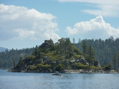
At Eagle Point we turn into Emerald Bay. You can see Fannette Island, the little pyramid shape in the center of the photo. Vikingsholm Castle is at the head of the bay. The castle was built in 1928-1929 by wealthy Mrs. Lora Josephine Knight. She felt the bay looked like the fiords of the Scandinavian countries and was inspired to build a Scandinavian style castle. It's now a California State Park.
 |
| Vikingsholm. |
There are two ways to get to Vikingsholm. You can kayak in as we did or hike down to the bay from the Highway 89 at the Eagle Falls Trailhead. Tickets to tour the castle can be purchased at the ticket booth at the trailhead. It's $10 for parking, $10 for adults and $8 for children. The parking lot has limited space. At the parking lot a well maintained trail descends steeply about 1,000 ft. from 6,300 ft. to the shore of Emerald Bay.
 |
| A group waits outside the castle for the next tour. |
We land on the lovely beach in front of the castle and walk around the building to look at the architecture. It was very busy and we didn't take the time to get on a tour but it would be well worth doing. We did some peeping in the windows and the interior is beautiful.
 |
| Vikingsholm Castle. |
 |
| Vikingsholm Castle. Isn't this an intriguing room? |
 |
| The wonderful architectural details of Vikingsholm Castle. |
Kayaks and paddle boards are available for rent so you can paddle around the bay and around Fannette Island, the only island in Lake Tahoe.
 |
| Fannette Island with the Vikingsholm Tea House. |
Fannette Island with the Vikingsholm Tea House perched on top looking east toward the mouth of the bay. Mrs. Knight was of English descent and went to the island every day for tea.
 |
| Visitors can rent paddle boards and paddle out to Fannette Island. |
 |
| Vikingsholm Tea House look out across Emerald Bay. |
A paddle boat brings visitors across Lake Tahoe from Reno to cruise around Emerald Bay. There isn't a dock so visitors can't disembark to tour the castle.
 |
| A paddle boat brings visitors across Lake Tahoe from Reno. |
 |
| As we paddle back out into lake Tahoe we join a flock of Canada Geese. |
As we leave Lake Tahoe we stop at the Eagle Creek Trailhead parking lot to view Emerald Bay from above. It's a real jewel.
 |
Emerald Bay and Fannette Island.
 |
| Fannette Island with Vikingsholm Tea House on the left peak of the island. |
|
 |
| A view of Vikingsholm Castle from the Bayview Trailhead overlook on Hwy 89. |
We leave Lake Tahoe and travel south heading for Yosemite. At South Lake Tahoe we take 89 south to 88, a meandering scenic drive over 8, 573 ft. Carson Pass in the Sierra Nevada Range. At Jackson we junction with 49 then take 26 from Mokelumne Hill to 12. A short distance on 12 near Valley Spring is the New Hogan Reservoir, a US Army Corps of Engineers site, where we'll spend the night at Acorn Campground.
 |
| Our quiet site over looking New Hogan Reservoir. |
Acorn Campground has paved interior roads and sites, flush toilets, token-operated showers, fish-cleaning stations, a dump and water taps throughout the campground. It's the middle of the week and the campground only has a couple other campers. It's busy on the weekend. The lake was very low as all the California reservoirs have become and the boat ramp at the campground was out of water. It's a great place to spend the night if you're on this route. It's also good birding.
 |
| New Hogan Reservoir is very low and some of the boat ramps are out of water. |
From New Hogan Lake we travel to Yosemite. Very exciting since the National Parks are on our bucket list. We backtrack on 12 to San Andreas and head south on 49 until it junctions with 120 where we'll take the Big Oak Flat Road into the Yosemite Valley.
 |
| Our first view of the Yosemite Valley. |
We don't stand a chance of camping in Yosemite so we have lunch at Cathedral Beach where we can sit and watch the climbers on El Capitan. We'll camp at a Forest Service Campground south of the park and come back through Yosemite to bicycle the park after we visit Kings Canyon and Sequoia National Park.
 |
| El Capitan raises it's imposing shoulder over the Merced River that flow through the valley. |
 |
| We have lunch on Cathedral Beach and watch the climbers who are half way up the wall through binoculars. |
 |
| Jim gets some fairly good photos of the climbers with his scope/camera. |
 |
| The photo is a little fuzzy but then the climbers are really far away. |
 |
| Yosemite Falls. |
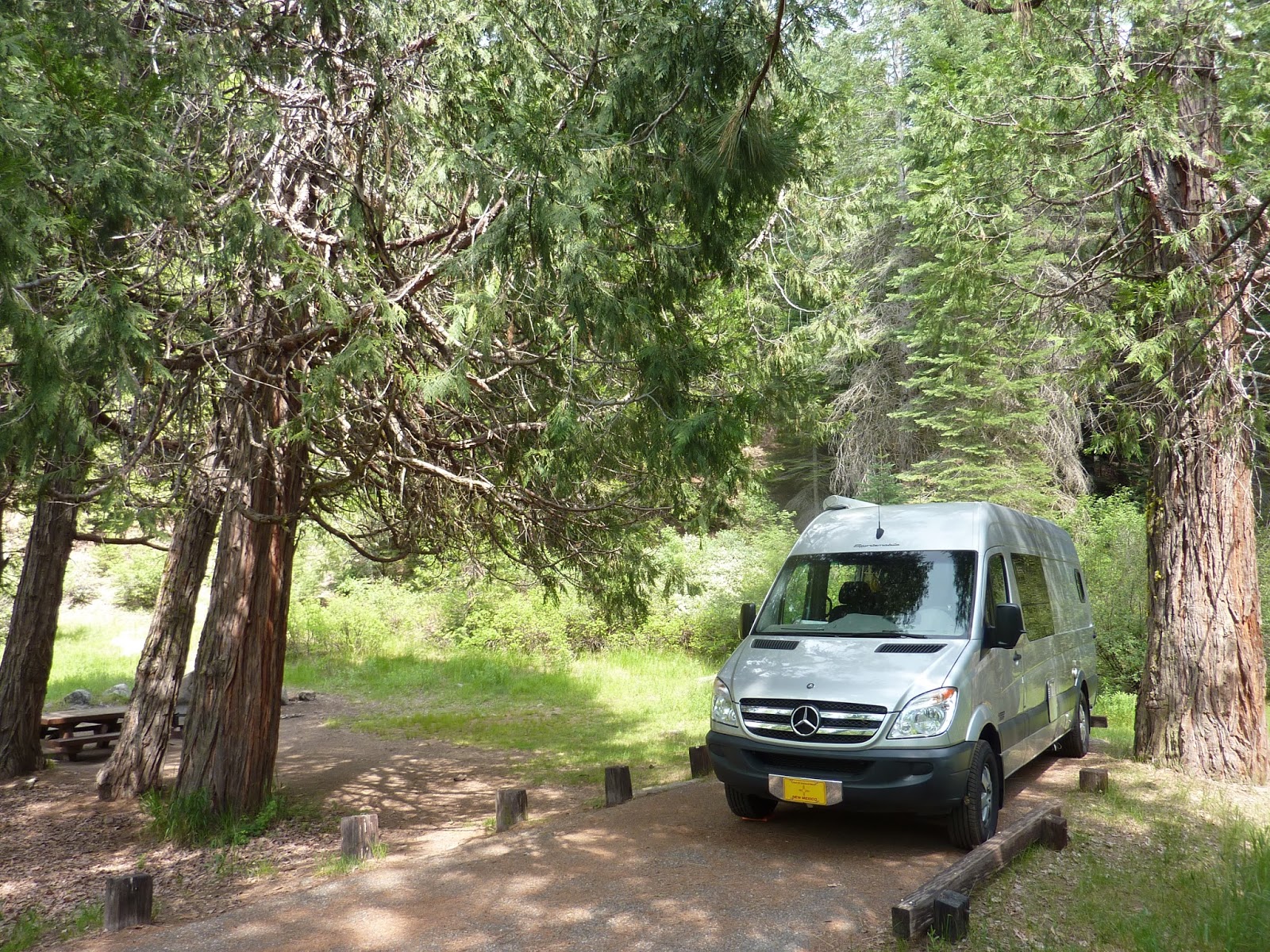
We head south from Yosemite on 41 to Summerdale, a Sierra National Forest Camp near Fish Camp just outside the National Park boundary. If you can't find camping in Yosemite this is a good alternative. It's a nice little forested campground near a stream. The roads and sites are paved and the sites are nicely spaced out but narrow. There are vault toilets and water faucets but no dump station. The cost is $28 per night or $14 with the Senior Pass.
 |
| Summerdale Sierra National Forest Campground. |
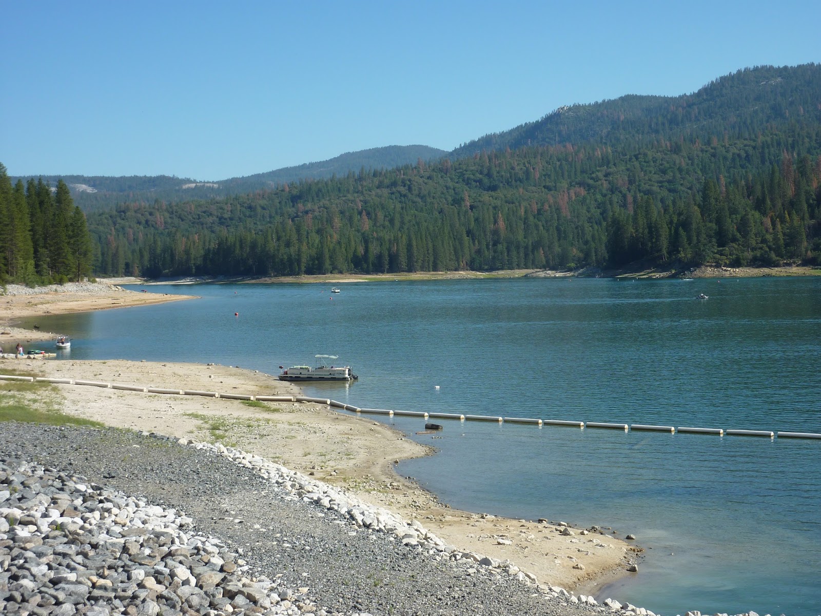
We decide to spend a few nights at Bass Lake thinking it would be a good place to kayak. It's only a short distance from Sunnydale CG and we want to get there early because it's Friday and campgrounds can fill up on the weekend. We continue south on 41 and take the Bass Lake Road at Yosemite Forks.
We camp at Lupin-Cedar Bluff Forest Service Campground for 2 nights. As with most campgrounds in California, the interior roads and sites are paved, there are flush toilets, token-operated showers, and water faucets scattered around the campground. There is one dump station along the Bass Lake Road near the Ranger Station. The trouble with the campgrounds next to the lake is that you hear the power boats all day and by the afternoon you can smell the exhaust. The weekdays may be better. The cost is $31.05 or $15.54 with the Senior Pass per night. I forgot to take a photo of our campsite.
The kayaking wasn't appealing. The lake is low with a rocky shoreline, a few beaches and no wildlife habitat to explore. It's a popular recreation lake and there were lots power boats which we should have expected being so close to Fresno. People come here on the weekends to beat the heat. There are several lodges, and boat and kayak concessions along the lake .
We're already committed to 2 nights so we decide to bicycle the local rural roads in the area. To our surprise they turn out to be good biking. Most of the pavement is fairly new or resurfaced, traffic is light, there are good climbs and the forested scenery and wildflowers make a pleasant ride. We rode a 16 mile loop the afternoon we arrive and an 18 mile loop the next morning before it got hot.
 |
| Low water at Bass Lake near the dam. |
Now on to our next destination, Kings Canyon and Sequoia National Park. From Bass Lake we follow the North Fork Road to Highway 41 and buzz on into Fresno, a great place to resupply.
Sportsmobile has a factory and showroom here and while we were shopping at Costco the CEO of Sportsmobile West, Alan Feld, put a business card on our window. It was Sunday and we didn't have the opportunity to visit them which would have really been a treat. Wish we could have met him.
In Fresno we take 180 east toward Giant Sequoia National Monument and Kings Canyon National Park. It's amazing how much elevation gain these highways that climb into the Sierra Nevada Range have. They rival Colorado's mountain passes. Fresno is at 296 ft. and the Kings Canyon Visitor Center and Grant Grove Village are at 6,600 ft. Hmmm. Where did I get the idea the Sequoias were in a valley? Here they are on top of a formidable mountain range.
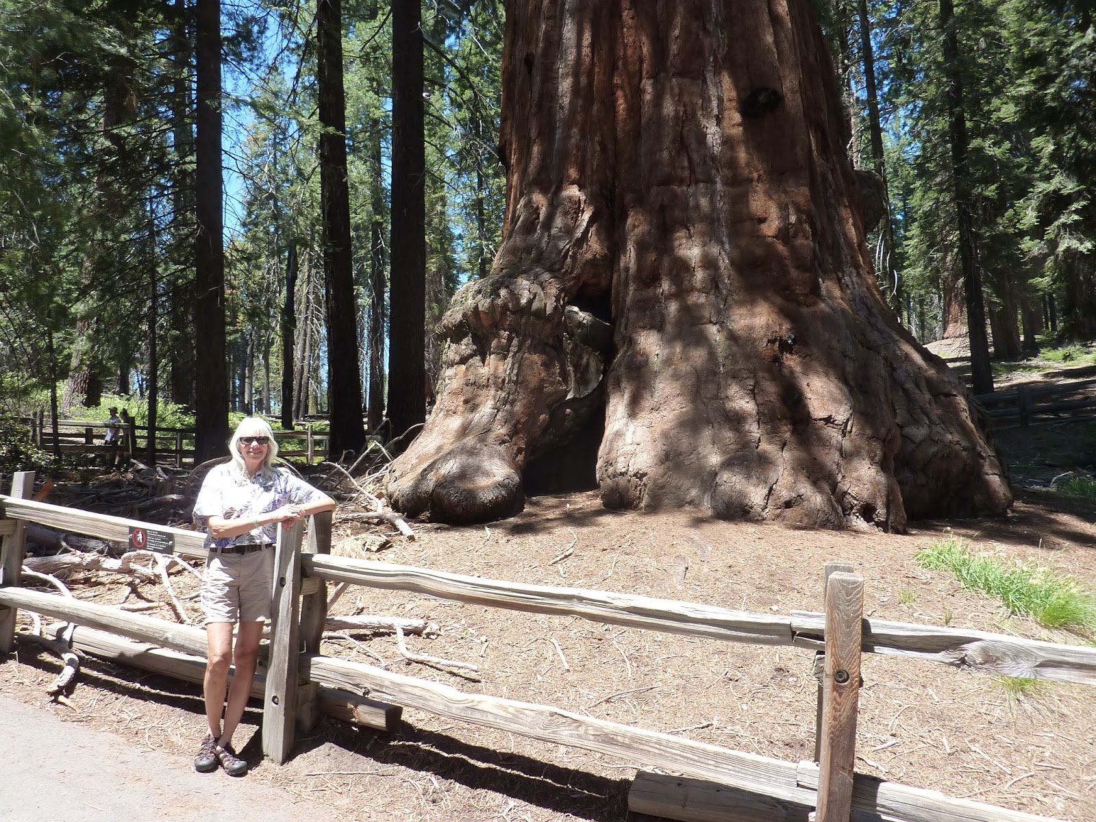
This is our first visit to the Giant Sequoias and they are spectacular. Not as tall as the Redwoods but certainly larger in girth. We take a short hike to the General Grant Tree before continuing on to Kings Canyon to camp for the night.
 |
| Spectacular Sequoias. |
 |
| Along the General Grant Tree trail you can walk through the hollow trunk of a fallen Sequoia. |
 |
| Me and General Grant. |
We continue on 180 and descend 2,000 ft. on the winding road into Kings Canyon.
 |
| Highway 180 descending into Kings Canyon |
There are several campgrounds some of which are only open during the busiest times and one that is for tenters only. We camp at the Sentinel Campground near Cedar Grove Visitor Center and Village. Like all the others it is paved with flush toilets, token operated showers, water faucets throughout the campground and a dump station. The sites are scattered in the tall pines along the South Fork Kings River. The cost is $18 or $9 with the Senior Pass per night.